10 Insanely Mysterious Places in Africa You Never Knew Existed
Let’s visit the 10 weirdest and insanely mysterious places in Africa. Fasten your belts, because this flight might get spooky.
A continent of 54 countries, over 5,000 languages, about 3,000 tribes with distinct cultures and belief systems, a unique bio-diversity and geological composition, amazing variety of wildlife, early civilisations, habitats, climate, and arguably the longest river and largest hot desert in the world, Africa is home to many fascinating and awe-inspiring experiences, and weird mysteries are surely not missing on the list. The continent naturally reeks of phantasmagoria.
From monuments to mountains, rivers to lakes, artefacts to architecture, ancient scripts to wall carvings, volcanoes to abandoned sites, Africa is home to a repository of wonders, and as you will now learn, mysteries too.
While a few of these have left the world awed and stunned, others have, unfortunately, broken the hearts of many, leaving behind trails of destruction, and human and livestock carnage.
Let’s visit the 10 weirdest and insanely mysterious places in Africa. Fasten your belts, because this flight might get spooky.
1. Dallol Volcano: Hell on Earth
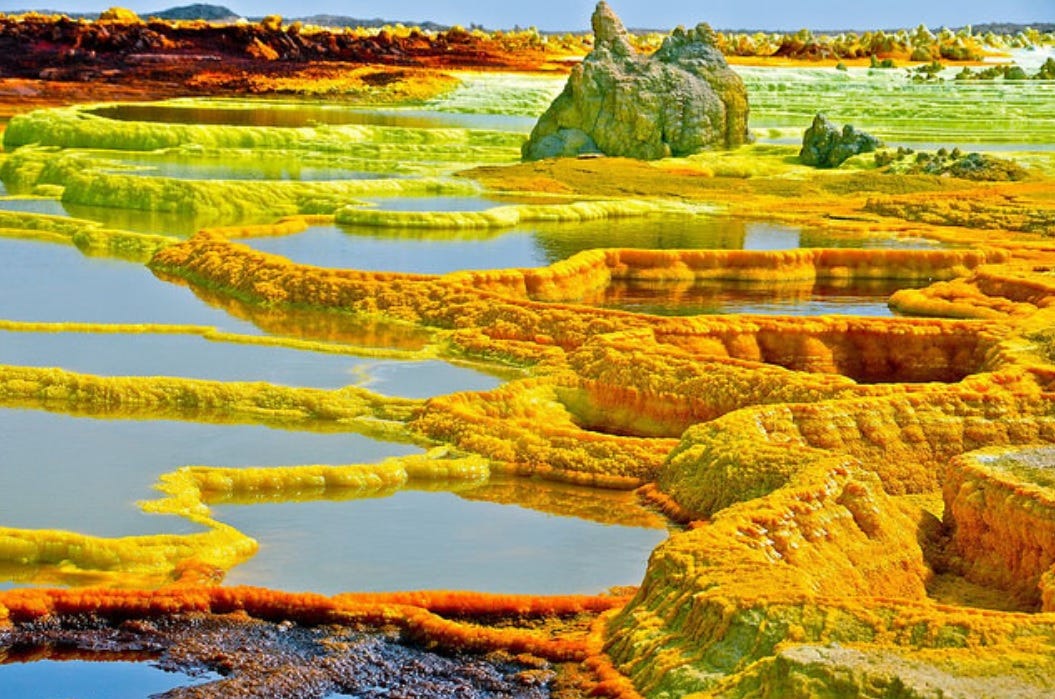
Do you remember US singer, Belinda Carlisle’s 1987 song titled, “Heaven is a Place on Earth“? Indeed, planet earth is arguably the most beautiful planet in the universe. Her lush green natural landscape, majestic rivers, picturesque natural and man-made architecture and best of all, habitability, confirms this. Still, it’s incomplete without adding that hell is also a place on earth.
Our "hell on earth" is located in Dallol, Ethiopia, where the Dallol volcano area has been dubbed the hottest place on earth, with an average daily temperature of 94°F.
Located in the north-eastern part of Ethiopia, Dallol, a name that was given by the Afar tribe to mean ‘dissolution’ or ‘disintegration’, was formed by numerous hydrothermal and phreatic eruptions which took place in 1926. This ghost-town is the hottest place on earth based on annual temperature averages, rather than isolated incidences of extreme temperature.
Another unwelcoming alien-like trait of Dallol is its high humidity of about 60% and the lethal fumes that rise out of its blazing sulfur pools. Just when you thought nothing could be worse, the Dallol only receives 100 to 200mm of rainfall annually and being -410ft below sea level makes it one of the lowest places on earth also.
Geologically characterized by volcanoes, bubbling lava lakes, neon-yellow and multi-coloured hydrothermal fields, great salt pans that awe the eyes, the Danakil Depression and micro-organic creatures called extremophiles -like their name, are suitable for extreme conditions- this brisking making of nature is cause for many paleontological and extraterrestrial studies.
If you wish to visit this ghost-town, do take a lot of water, light clothing, beware of sulfur outbursts, and don’t plan to stay long.
2. Lake Natron: Blood-Red Lake
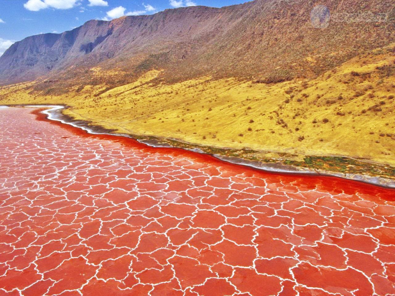
Located in the Arusha region of northern Tanzania, Lake Natron is a salt and soda lake. Temperatures at the lake are frequently above 40 °C (104 °F), and its neighbouring area receives irregular seasonal rainfall, mainly between December and May, totalling 800 millimetres per year.
It is generally said that toxic and saline soda lakes are a paradise for flamingoes, but Lake Natron is anything but paradise for these birds. Due to high levels of evaporation, Natron’s deposits have left the place a highly concentrated caustic alkaline grave for birds.
Located close to the Kenyan border, Lake Natron contains peaking alkalinity, with a pH of 9 to 10.5. For the sake of context, Madagascar’s lakes have an average pH between 7 and 9, but it is extreme for this lake. With its alkalinity, combined with a temperature of 140 degrees Fahrenheit, the blood-red lake is toxic enough to poison most animals.
Writing in his photo book, photographer, Nick Brandt noted:
“The water has an extremely high soda and salt content, so high that it would strip the ink off my Kodak film boxes within a few seconds. The soda and salt cause the creatures to calcify, perfectly preserved, as they dry. In other words, animals that become immersed in the water die and are calcified.”
3. Richat Structure: Giant Blue Eye of Africa
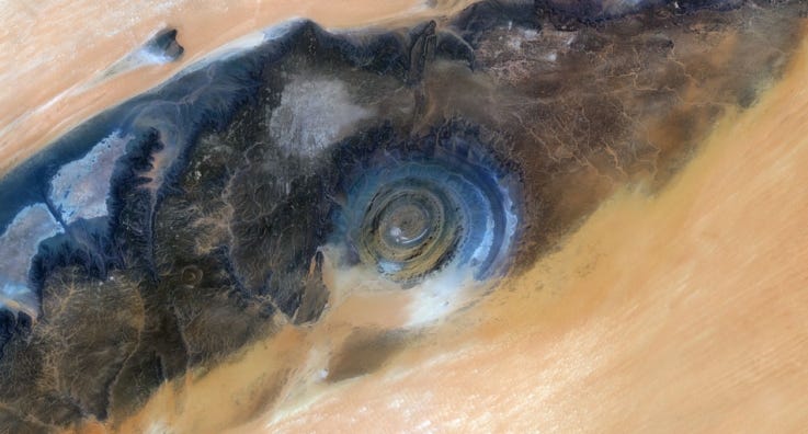
Located in Oudane, west-central Mauritania, the Richat Structure, also fondly called the Giant Blue Eye of Africa, is a prominent circular formation of geological wonder formed in the heart of the Sahara desert. Best viewed aerially with satellite images from space, this geological phantasmagoria is appealing to many, yet, mysteriously unbelievable to others.
Initially interpreted as a meteorite impact structure because of its high degree of circularity, this source of decades of scientific inquiry and mystery is now regarded by geologists as a highly symmetrical and deeply eroded geologic dome. After extensive field and laboratory studies, no credible evidence has been found to be indicative of any extraterrestrial impact or activity.
Probably the most comprehensive and widely accepted scientific explanation to this formation is the one presented by two Canadian geologists, who theorized that the Eye’s formation began more than 100 million years ago during the continental drift era when plate tectonics divided Africa from South America. Years after, the Eye, according to them, erupted violently, collapsing the bubble partway, and erosion took place, to create the Eye of the Sahara that we know today.
While some believe that the Giant Blue Eye is actually the remains of the city of Atlantis which Plato described as circles of water and land, others surprisingly believe it to be a hole, formed during the biblical deluge of Noah, when God flooded the earth with water.
However the case, this strange mystery, as pictured from space by astronauts, continues to intrigue and marvel the world.
4. Egypt’s Abandoned Apocalyptic Theatre
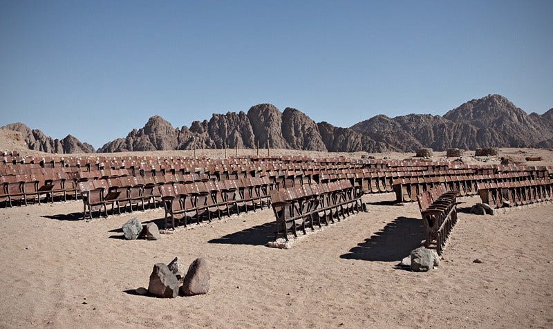
Around the world, there exists eerie and strange images, footage, sounds and stories that provoke the grizzling fear and paranoia of the apocalypse. One of these many phenomena is the eerie abandoned outdoor theatre in Egypt.
On the northern cape of the Sina Peninsula in Egypt, lies a cluster of about 150 seats for an outdoor movie cinema that is yet to screen its first movie.
According to Kaupo Kikkas, Estonian photographer, who visited the abandoned location, the theatre was built sometime in the beginning of this millennium by a French man, who, while at the Sinai Desert with his legion of friends, decided to build a movie theatre there. He was said to have been driven by the business motive to replicate what he had seen in Europe and make tons of cash from it.
So, they brought in hundreds of old wooden seats with engraved markings, a generator and a giant screen for the projector that looked like a ship’s sail form Cairo.
Soon enough, upon completion, the cinema was ready and a grand party was planned for its launch. Everything was set for opening night, however, the natives didn’t like the idea for some unknown reason and vandalised the generator. Not a single movie was, and would ever be screened there.
Recent pictures from Noha Zayed, an Egyptian tourist who visited the site shows that it now lies in ruins. She wrote in a Facebook post:
“So we decided to find and visit the cinema at the end of the world. Upon arriving at the site, we thought we got our coordinates wrong. The chairs were all knocked down as if on purpose. The place had been shattered, levelled and destroyed; the site disintegrated. It was quite a disappointment. Sorry to burst the bubble.”
Existing or not, this site surely was one with a mysterious disappearance.
5. Nyiragongo: World’s Deadliest Lava Lake
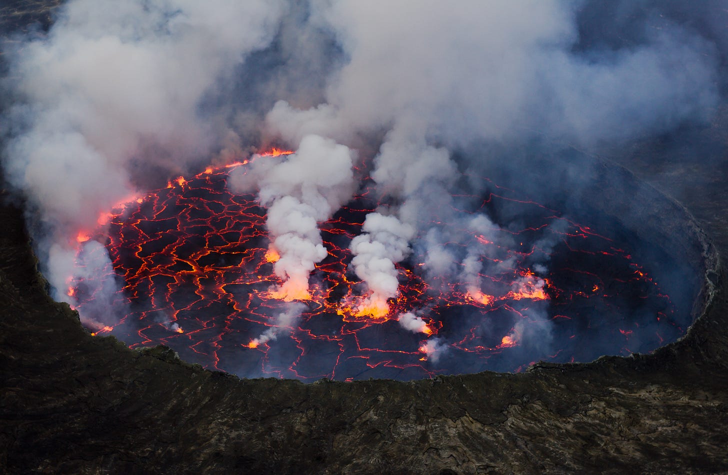
Mount Nyiragongo is an active stratovolcano with an elevation of 3,470 metres, and located in the Virunga National Park that hosts the Virunga Mountains, near the town of Goma and Lake Kivu in the Democratic Republic of the Congo.
Nyiragongo’s lava lake has, at times, been the most notorious lava lake in the world in recent history on many parameters, including width, depth, the deadliness of its magma lava and its threat to the Goma people who live around the foot of the mountain, the number of eruptions, as well as the lives it has claimed so far.
The lava lake in the centre of the volcano is around 700 feet wide and geologists say it could be miles deep. Nyiragongo Lake is filled with hot magma.
Volcanoes are deemed dangerous by the threats they pose, but what makes Nyiragongo the most dangerous volcano in the world is that asides its super-fast and hot lava flows that drain into nearby towns like Goma, its volatility still remains a mystery undecipherable by scientists due to political tensions in the Congo, and as such, no one has been able to exhaustively research about the lake or predict any future eruption.
Such eruptions have, in total, occurred 34 times, making it the most active volcano. Two of such dangerous eruptions occurred in 1977 and 2002. It is still unknown how long the lake has been active, but the first eruption in record was in 1882.
In 1977, during its most catastrophic eruption, the walls of the crater burst open and the lake of molten rock drained in less than an hour, pouring itself down into the villages at a terrifying speed of up to 60 mph.
Unlike average lava flows, Nyiragongo’s unique composition of an alkali-rich volcanic rock, melilite nephelinite, and carbon dioxide toxicity, locally known as ‘mazuku’, allows it to move at speeds, fast enough to turn a whole city into ashes.
While the official death toll after the eruption was 70, many claim over a thousand lives may have been lost.
As much as it sounds unbelievable to think that people would want to inhabit the bottom of a steep volcano that hosts the world’s largest and deadliest fluid lava lake, the area at the foot of Mount Nyiragongo is dotted with highly populated bustling villages.
This imminent human threat is part of what makes it the most dangerous lava lake in the world.
6 . The Shifting Sand Dunes of Olduvai Gorge
Olduvai Gorge, in Tanzania, is undoubtedly one of the most significant paleoanthropological sites in the world, uniquely positioned on the road from the Ngorongoro Crater to the Serengeti National Park.
Famous British-Kenyan paleoanthropology-archaeologists, Mary and Louis Leakey established and developed the excavation and research programs at Olduvai Gorge which discovered that the Homo habilis, one of the earliest human species, occupied Olduvai Gorge, approximately 1.9 million years ago, then an australopithecine, Paranthropus boisei, 1.8 million years ago, Homo erectus, 1.2 million years ago, and finally, the Homo sapiens is dated to have occupied the site 17,000 years ago.
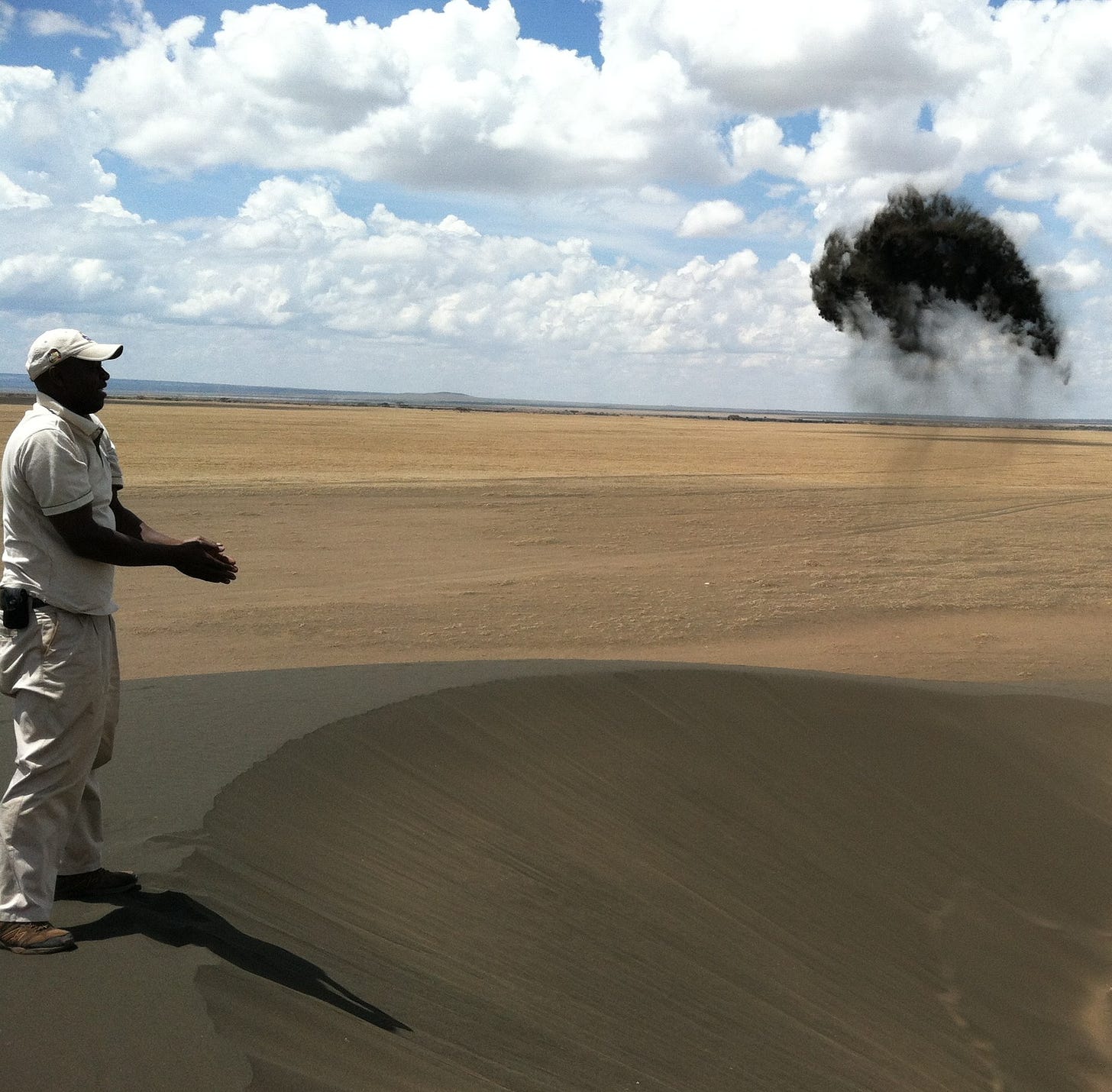
Technically referred to as “barkan”, these crescent-shaped dunes are a rare phenomenon, and are formed when the volcanic ash (or dust) simply gathers around a rock, accumulates over-time on the ground and a unidirectional wind blows onto it to create the moving effect.
This process is continuous and allows the sand dunes to move around 10 meters a year. There are currently markers to indicate where the dunes were five, ten, twenty and decades ago.
More mysteriously, at first sight, it’d look like aliens must have left the dunes behind. This is so because the sand is not only very fine and black, but also highly magnetic due to its high level of iron content. For instance, if you grab and toss a handful of it up in the air, rather than blowing away dispersedly, it glues together and falls back onto the dune almost undivided.
Local Massai myth has it that the sand dunes originated from Ol Doinyo Lengai (Mountain of God), the holiest place in their culture.
7. Tsingy de Bemraha National Park: Madagascar’s Stone Skyscraper City
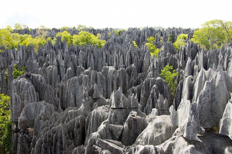
The Tsingys, otherwise called Madagascar’s Stone Skyscraper City or Stone Forest, are karstic plateaus located in the Tsingy de Bemaraha National Park, in the Melaky Region of northwest Madagascar.
This UNESCO World Heritage Site features karstic landscapes and limestone uplands distinct by ‘tsingy’ peaks and a ‘forest’ of knife-shaped limestone; the spectacular canyon of the Manambolo River; and the rolling hills and high peaks.
Divided into Petite Tsingy and Great Tsingy, the Tsingy is a 250-square-mile and 120-meter tall upland, made up of massive limestone obelisk edges with spiky sharp peaks. The Tsingys are also home to some of the world’s most diverse wildlife.
In Madagascar, where 90% of its species are found nowhere else on earth, the largely uncharted park is a bio-fortress, charted only by ‘bare-feet’, as is the English translation of the Malagasy word, ‘Tsingy’.
Now, how were these spiralling karsts formed? Interestingly, these karst formations came about due to soluble limestone that was conditioned and shaped by high rainwater and streams. The exact processes that carved them are complex, rare and quasi-mysterious.
Geologists argue that underground water scoured the limestone beds, creating caves and tunnels, while the rock dissolved. Today, many of these caves and canyons are so tight that it’ll only take slender and slim humans to pass through them.
These karst limestone formations have become like arranged rows of skyscraper apartment buildings. Almost the limestone equivalent of Manhattan in New York.
As they spiral into the sky in dispersedly arranged and clustered fashion, they also provide shelter to an array of endemic species like the white-furred Decken’s sifaka lemurs at each level.
Tsingy de Bemaraha is reachable, but due to its rough terrain, can only be accessible by road from the town of Morondova.
Best visit period is during the dry season between April and November. Still, it’s advised that anyone visiting the park hires one of the park’s guides provided by the park management.
8. The Ruins of Gedi: Africa’s Lost Stone City
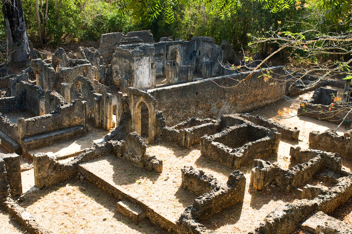
The Gedi ruins are one of Kenya’s greatest mysteries. Located in an idyllic site on the Indian Ocean, and buried deep in an almost forgotten forest, are the Ruins of Gedi, one of Kenya’s and, indeed, Africa’s greatest historical and archaeological mysteries.
Believed to have been founded in the early 13th-century, these ruins remain a mystery, as there are no hard evidence or written document to prove the existence of a thriving human community here.
What has, however, really baffled historians and archaeologists is the town’s well-established technology, urban settlement pattern (evidence of streets, sewage, public baths, houses, a palace, several mosques, running water, etc.), archaeology and commercial activities.
This, now eerie and abandoned Swahili-Arab city, has, due to its mystical nature, left room for many conjectures that seek to explain its abandonment. While some claim that the city was sacked by unknown invaders, others counter-claim that the inhabitants, believed to have numbered c.2,500 people, abandoned the city due to the receding waters of the Indian Ocean, which caused water shortages.
More strangely, others argue that the entire Gedi population was wiped out due to a Black Plague disease believed to have been brought by Portuguese explorers.
While these conjectures are lacking in both historical fact and archaeological evidence, the consensus remains that there is still no consensus on the reason the Gedi people abandoned their impressive city.
James Kirkman, one of the earliest excavators at the site makes this mystery even spookier with this submission:
“When I first started to work at Gedi, I had the feeling that something or somebody was looking out from behind the walls, neither hostile nor friendly, but waiting for what he knew was going to happen.”
Scary enough?
9. Tiebele: Burkina Faso’s Art Village
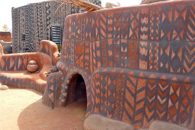
African architecture is close to nature and its related phenomena. In many instances, this is evident in house patterns, paintings, graffiti, and many more.
Located in the south of Burkina Faso, a landlocked country in West Africa, and near the border with Ghana, is this beautiful village of Tiebele. The native Kassena people, one of the oldest ethnic groups that had settled in what is today called Burkina Faso in the 15th century, built their houses using local materials such as clay, coal, chalk, wood, and straw.
After mixing soil with straw, and cow dung is dissolved, the men begin to shape these materials along vertical surfaces until there is a mold, good enough for construction and wall plastering. Today, however, the use of mud brick molding walls with strong foundations resting on large stones has replaced the older technique.
Tiebele’s houses are built with a mind for defence, whether it was for protection from the weather or from potential invaders. Walls are over a foot thick and the homes are designed without windows, except for a small opening for the sake of sight, sunlight, and ventilation.
Quite mystically, after a house is built, the inhabitant first waits for two days, and if the house is ‘visited’ by a lizard, it is deemed a good house, but if not, the house is deemed badly built, cursed and then destroyed.
Another interesting detail about the Tiebele houses is that every painted house is unique in painting and pattern, with unique symbolic significance, too. These paintings are exclusively done by the local women who use different local natural materials for colouring, from grounded earth to volcanic rock.
To preserve these paintings from fading, the women renovate house exteriors once in four years during the dry season in preparation for the rainy season.
10. Lake Nyos: Cameroon’s Deadly Gas Lake
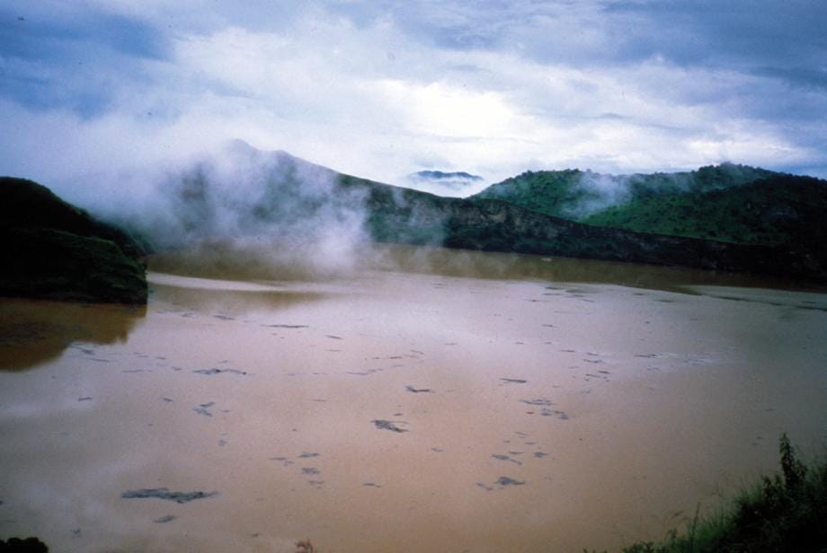
Located in the village of Nyos, North-western region of Cameroon, and notoriously nicknamed “the Killer Lake,” Lake Nyos conveys a proverbial folklore of death, danger, and local folklore.
This tale has it that the lake is possessed by an evil spirit which caused the last disaster that killed all those who lived near it. Indeed, this folklore is informed by a very real threat.
Being a crater lake, formed from geological aftermaths of volcanic activities in itself, it would not be unusual for Lake Nyos to contain some high levels of carbon dioxide. What was unusual, however, was the extremely and bizarrely high levels of carbon dioxide that the lake contained and dissipated on 21st August, 1986, when it triggered a disaster that claimed over 1,746 lives.
This unfortunate disaster occurred when a limnic eruption triggered an explosion (scientists are still unsure what caused the eruption) that immediately released about 300,000 tons (some accounts say 1.6 million tons) of carbon dioxide.
Only 6, of the 800 villagers at Nyos survived the disaster. Official casualty figures left over 1,700 people dead, and more than 3,500 livestock lost forever.
One survivors, Joseph Nkwain, had this to say after the disaster:
“I could not speak. I became unconscious. I could not open my mouth because then I smelled something terrible… I heard my daughter snoring in a terrible way, very abnormal…When crossing to my daughter’s bed… I collapsed and fell…My arms had some wounds, I didn’t really know how I got those wounds. I wanted to speak, my breath would not come out…My daughter was already dead.”
Today, amidst degassing attempts by scientists, an installed pipe that allows gas from Lake Nyos to escape into uninhabited locations, and a dam constructed to manage the outgassing of the lake, the lake, as sources show, is at an all-time peak, higher than the 1986 level.
It is feared that if outgassed, the dam would be unable to contain it. It is now a question of when the next outgassing would occur.
Unhooking your seatbelts…
So, there you have it. The 10 Insanely Mysterious Places in Africa You Never Knew Existed.
You can now heave a sigh of relief. The danger is over, the mysteries have been told and our trip has come to an end.
See you in the next listicle!


